Green Peter Dam
The Beautiful Willamette
From the Cascades’ frozen gorges, Leaping like a child at play, Winding, winding through the valley, Bright Willamette glides away; Onward ever, Lovely river, Softly calling to the sea, Time, that scars us, Leaves no track or trench on thee—
—Samuel L. Simpson (1845-1899)
Seventy percent of Oregon’s residents live in the Willamette Valley, most within a 20 minute drive of the Willamette River. These Valley residents live in harmony with the river all along its 187 mile journey as it travels from just south of Springfield and flows north to spill into the largest river in the Pacific Northwest; the Columbia.
The Willamette valley is cradled by mountain ranges on three sides: the Cascade mountains on the east side, the Coastal Range on the west, and the Calapooya Mountain range to the south. In past years it was not unusual for flooding to occur in the valley, especially between December and February when snow would come to the mountains in late fall or early winter, a warm spell would light on it, and the snow melt would run off into the Willamette’s tributaries causing the Willamette River to rise and send all of its riverside inhabitants scurrying to higher ground. It was not long after settling in the area that the earliest Euro-Americans experienced a deluge from what is known as the Willamette’s 100 year flood tendency, quickly and surely learning how mighty the Willamette can be.
On December 6, 1861 the Willamette River flooded the town of Champoeg as well as other towns along its labyrinthine banks. This flood was so great that the course of the river was permanently altered, causing people to move in order to stay close to the river which they depended on as a major transportation network. Farmers needed to transport their wheat to Portland and Vancouver for distribution to California and Russia, there was a water-powered grist mill operating on the river, and many steamboat landings were used by passengers for the transport of livestock, produce, and other goods.
Unlike the native Kalapuya, who were stewards of the valley long before the settlers arrived and were quite mobile, the Euro-Americans were intent on building a permanent residence. By 1861 Champoeg was a bustling center for commerce with a steady population of 200 people working in stores, as blacksmiths, running livery stables, saloons, a hotel, churches, a school and other services such as health care and carpentry. Very little was salvaged from the area after the great flood rescinded. It was with this flood that the Willamette River introduced itself to the settlers with a colossal force.
Thirty miles South of Champoeg sat a town west of Salem called Eola that was forever lost to the great flood of 1861. Eola was a thriving river town until the flood changed the course of the Willamette River and drowned it out. Eola was settled by Joshua Shaw and his son, who were the first to bring sheep overland to the Oregon Country along the Oregon Trail (1844). Upon arriving, they called the town Cincinnati, for it so resembled the town where Joshua once lived.
Within a few years of arriving in Eola (Cincinatti), Abigail J. Scott became the town’s first school teacher though she had very little education herself; having gained much of her knowledge from reading books along the trail to Oregon. It is this very same Abigail J. Scott who later became Abigail Scott Duniway, Oregon’s leading suffragist.
The Willamette River has a long, well-documented history of flooding the valley:
1861: is the largest flood of the Willamette River on record.
1890: was a very significant flood.
1964: the “Christmas Flood,” rated by FEMA as a 100 year flood. $157 million in damage and 20 people lost their lives.
1996: flooding occurred despite the use of the dams along the tributaries because of the extreme weather occurrences: rapid, deep snow in the cascades/mountain ranges the last two weeks of January, sudden torrential freezing rain for a few days, then tropical rain came through melting the snow pack and flooding areas where it pummeled frozen ground.
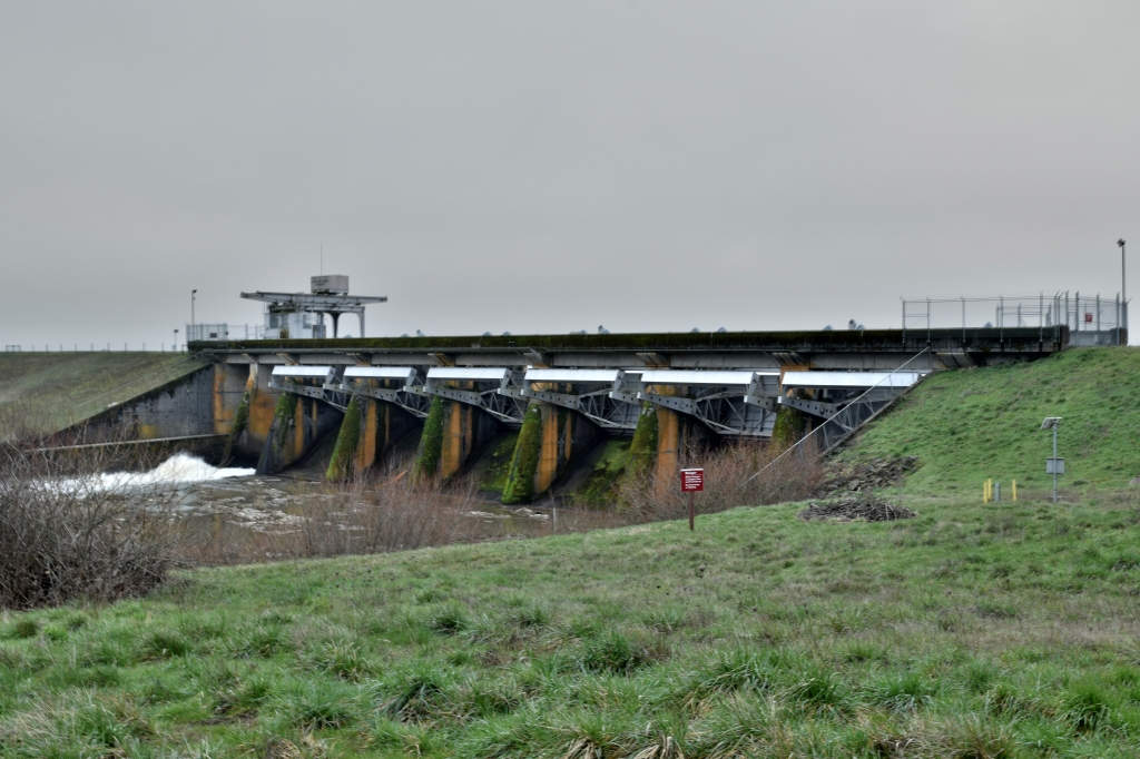
Due to its fertile plain, the Willamette Valley became more and more populated, but the threat of flooding was never far from thought. In 1936, Congress passed the Flood Control Act, which asserted that the federal government would aid in flood control on navigable waters. Soon the Willamette Valley Project was developed and over the next 35 years the 13 Willamette tributary dams would be constructed.
In 1941 the first of the Willamette tributary dams was completed. Along the Long Tom River, Approximately 12 miles west of Eugene, the Fern Ridge Dam and Lake is known to be an excellent spot for birding and viewing wildlife. It is operated primarily for recreation in the summer where water related activities abound. It is also an important element for flood control in the winter and is part of a major wildlife management area. Lane County runs five parks along the shores of Fern Ridge Lake, the Army Corps of engineers and the Oregon Fish and Wildlife operate a wildlife area as well as a park, and Fern Ridge Lake is home to the Eugene Yacht Club. All this can be found on this lake with a summertime area of 4.5 miles masterfully contained by a 6,330 ft. long, 44 ft. high earth-fill dam with a concrete spillway. Fern Ridge Lake is one of the most popular recreational spots in the region.
Cottage Grove Dam was built in 1942 on the Coast Fork Willamette River approximately 5 miles south of Cottage Grove. The lake is a popular area for boating, water-skiing, camping, and fishing. Analyses of fish tissue has shown disconcerting levels of mercury in the fish, likely due to Black Butte mine, just two miles away, which was once one of the largest producers of mercury in Oregon. Arsenic has also been reported in the area downstream from the dam at London Springs.
Dorena Dam was completed in 1949 along the Row River, about six miles east of Cottage Grove. It is a popular boating lake, lending itself more to sailing ventures than to the water skiers of nearby Cottage Grove Lake. The city of Cottage Grove rests where the Coast Fork of the Willamette River meets the Row River, and Silk Creek runs through the west side of Cottage Grove, all of which make Cottage Grove a prime target for flooding. Before Dorena Dam was built, flooding was nearly as frequent as rainfall in Cottage Grove, but thanks to the Cottage Grove and Dorena Dams, flooding is less of a threat.
At 463 ft., Detroit Dam, 1953, is the largest of all the Willamette River tributary dams and the first constructed with hydro-power capabilities, hosting two power generators. The first of the Willamette Valley Project dams to be built after WW11, the 110 MW producing dam is Located on the North Santiam River approximately 45 miles southeast of Salem. Detroit Dam was intended primarily for flood control and the generation of power, but the reservoir has become one of the most popular recreation sites in western Oregon. Measuring 9 miles, Detroit’s lake is nearly twice as large as Fern Ridge’s, yet its 735.000 yearly recreational visits only come close to the 768,000 visitors to Fern Ridge. All things boating, swimming, camping, and fishing are enjoyed at Detroit Lake. The U.S. Forest Service operates four campgrounds, and the Oregon Department of Parks and Recreation manage two parks on the Lake.
Big Cliff Dam was built in 1953 as a re-regulator of the water released from Detroit Dam just 3 miles upstream. The purpose of the Big Cliff Dam is to aid in providing uniform stream flow into the North Santiam River. With Detroit Lake so close and easily accessible, Big Cliff Lake is not considered a recreational facility because of its small size and that its high cliffs making it difficult to access.
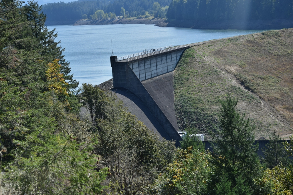
Lookout Point Dam, built in 1954, is located about 22 miles southeast of Eugene on the Middle Fork Willamette River. Lookout Point Lake is a very large reservoir extending for more than 14 miles along the Middle Fork of the Willamette River to the Calapooya Mountains S.E. of Eugene. Not only has this Dam, coupled with Dexter as its re-regulator, prevented hundreds of millions of dollars in damage, it is also an important dam for the production of hydroelectric power. The lake is a poor fishing area, but popular for other water and boating sports and is home to many species of wildlife and flora. The 3,381 ft. long embankment structure contains a 274 ft. long concrete spillway with 5 gates. Controlled releases of the water aid in water level control, power generation, and pollution control.
Dexter Dam was built in 1954 2.8 miles downstream from Lookout Point Dam as a re-regulator. Because of its ease of access, water-skiers, sail-boaters, and anglers make Dexter Dam a popular day use recreation area; more so than Lookout Point. Together, Lookout Point and Dexter Dams have prevented more than $5.3 billion in potential flood damage. Combined, they utilize four power generators responsible for generating more than 370 MWHs of electricity.
In 1961 Hills Creek Dam was completed on the Middle Fork Willamette River about 45 miles southeast of Eugene. Hills Creek is operated in conjunction with Lookout Point downstream to meet the flow needs on the Willamette River during the summer. Windsurfers, water-skiers, sailers, swimmers, canoers, kayakers, and anglers, all enjoy recreating on this reservoir’s 2,735 acre water surface. The 44-mile shoreline is managed as a wildlife habitat, with a 130-acre wetland area below the dam hosting fields, ponds, fowl, and beaver dams.
Cougar Dam, 1963-64, built on the south fork of the McKenzie River, is the highest embankment dam ever built by the corps, reaching 452 ft. above the stream bed. A rock fill structure with a concrete spillway, It houses two power generators. Cougar Dam has a temperature control tower which takes water from the reservoir and spills it into the river at a controlled temperature in order to facilitate the spawning of salmon. Near Cougar Dam is a national forest for hiking and the Cougar hot springs for relaxing.
Fall Creek Dam was built in 1966 on Fall Creek, a tributary of the Middle Fork Willamette River, approximately 22 miles southeast of Eugene. The lake is a popular spot for all manner of water recreation and the shores are a favorite for hiking and wildlife viewing.
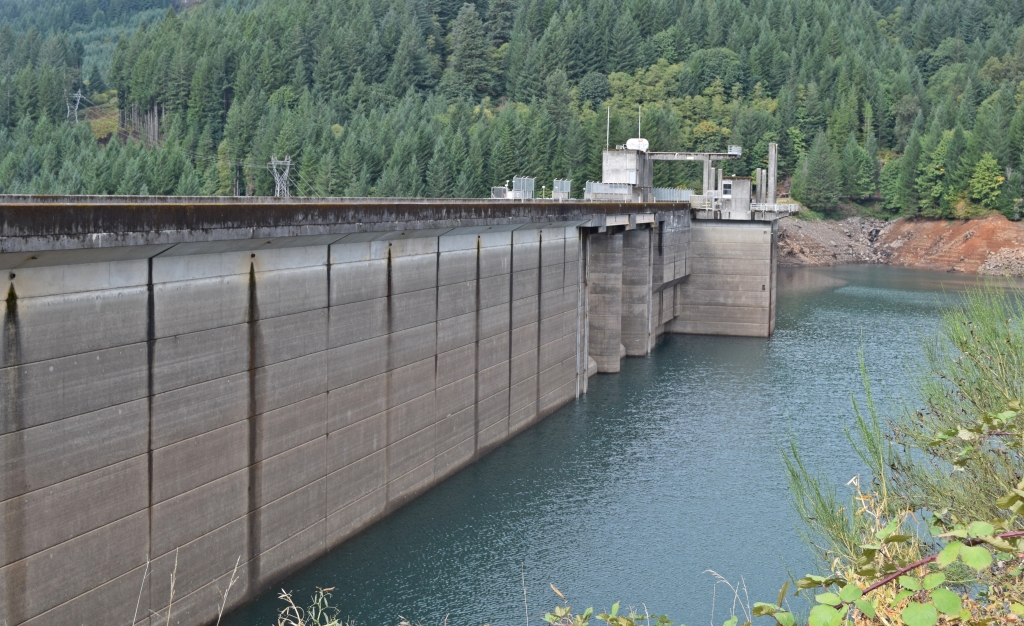
Green Peter Dam, built in 1968 on the Middle Santiam River, is a 380-foot concrete structure which has a gated spillway and two power generators. This dam is in a key location, resulting in the prevention of millions of dollars in damage since its completion. The reservoir, which is popular for boating and fishing, is known as western Oregon’s premier Kokanee fishing lake.
In 1968 Foster Dam on the South Santiam River was completed east of Sweet Home. It is a re-regulator of the water spilled from Green Peter Dam. Foster Dam plays an important role in storing water for flood control, irrigation, and power production. The reservoir is the most popular water-spot in the county, offering swimming, boating, fishing, camping, hiking and picnicking.
1969 brought the completion of the final dam of The Willamette Valley Project, first set to planning over thirty years previous. Blue River Dam is located approximately 38 miles east of Eugene on the Blue River, a tributary of the McKenzie River. The reservoir is a popular spot for fishing, swimming, water-skiing, and camping.
There has been no wide-spread, devastating flooding in the Willamette Valley since the completion of the dams, and the hydro-power generates enough electricity to power 300,000 homes. Many of the valley’s homes, farms, and businesses exist solely because the dams prevent the flooding of the Willamette River. Much of Oregon’s population lives, grows, and does business on the flood plain of the Willamette.
Niney-six percent of the land in the Willamette Valley is privately owned and 50% of that land is used for agriculture (including land used to raise livestock). All manner of produce is grown in the valley as can be seen at any local farmer’s market, where farmers proudly display everything from sweet, juicy, strawberries in the early summer to perfect, firm and flavorful squash in late summer and into autumn.
The Willamette Valley is the nation’s largest grower of hazelnuts and grass seed, is home to more than 500 wineries producing highly acclaimed wines, and is the second largest hop producing region in the United States. As of 2009 there are over 1000 Willamette Valley families enrolled in the Century Program, a program which celebrates family farms of 100 years or more. It is not a stretch to say that the valleys economy is driven by the tractor.
Almost 2/3 of the nation’s grass seed is produced in the Willamette Valley. Mild, wet winters and dry summers are an ideal climate for grass seed, an agribusiness that has grown to being produced on more than half of the total cropland in the valley. There are over 950 varieties of 8 different species of grass grown on 347,000 acres of the valley. “Oregon growers produce essentially all of the U.S. production of annual ryegrass, perennial ryegrass, bentgrass, and fine fescue. Smaller amounts, but significant portions of the USA production of Kentucky bluegrass , orchardgrass , and tall fescue, are also grown in Oregon. “ According to the Oregon Seed Council, “grass seed farming drives more than $1 billion in annual economic activity, ” and it employs up to 10,000 Oregonians.
Ninety-nine percent of the nation’s hazelnuts are grown in the Willamette Valley, a fact which is attributed to the unique combination of the valley’s rich soil, ample rainfall, and gentle climate. It is said that this unique combination contributes to the growth of the best tasting and most abundant hazelnuts possible anywhere. In recent years the region’s hazelnut trees have been suffering from the Eastern Filbert Blight, which has had the regions approximately 700 filbert farmers not only scrambling to solve the blight by treatments and pruning, but also has them planting new trees in order to keep up with the demand for the nut. Hazelnut growers produced 38,000 tons in 2016, generating well over $90,000,000 for the Oregon economy. Despite the struggle to keep ahead of the eastern filbert blight and the purchasing, planning, planting, and tending of new disease-free orchard stock, the hazelnut farmers remain optimistic that they will overcome this blight and that they will continue to produce nearly all of the hazelnuts grown in the United States.
Currently the only way to beat the blight is to continue to prune the affected areas off of the diseased trees. Once pruned to nothing, there will be no tree left, and hopefully the newly planted, disease-resistant trees will begin producing nuts by that time. This must take place for each tree which has contracted the blight on any of the 30,000 hazelnut-producing acres of the Willamette Valley. Hazelnut trees will usually begin producing nuts when they are two to three years old, but are not considered to be commercially productive until they are 4 years old, giving an overall appearance to the layperson of a race against time as the blight is taking the trees limb by limb and the farmers are propagating new trees nut by nut.
Oregon State University’s extension service has been developing a disease-resistant hazelnut tree, having identified 20 such strains from around the world, they are looking to find which will grow best in the Valley’s soil and climate. OSU is working in close partnership with Oregon Hazelnut Growers, as they adjust and conquer the plight of the blight, as can be viewed in an OSU video.
According to the most current statistics available, the vintners of the Willamette Valley produce 82% of the Pinot Noir made in Oregon, 73% of Oregon’s wine in general, and lays claim to 71% of Oregon’s wine-grape producing acreage. Though the climate is cool all up and down the valley, there are variants in temperatures as vineyards climb hillsides or lay upon the valley floor and there are different soils ranging from marine sedimentary, to volcanic to windblown loess, each attributing to its own distinct and sought-after flavor. It is reported that the wine industry in Oregon contributed either directly or indirectly $3.35 billion in 2013 to the Oregon economy, a majority of that wine-making and grape growing taking place in the valley, home to more than 500 wineries, most of which are located in the northern Willamette Valley region.
The unique growing conditions of the Willamette Valley, perhaps the most diverse in the world, can be attributed to not only the ample rains and cyclic vegetation, but also the past floods of the Willamette River combined with the flash burning practices of the indigenous Kalapuya. These natives of the Valley were expert caretakers of the land. Numbering around 15,000 members at the time of the arrival of the first white explorers, the Kalapuya used pyroculture to form the distinct areas where camas, hazelnuts, acorns, wapato, and berries were harvested for their sustenance. In the vast meadows formed by their flash-burning practices, deer and elk grazed where the Kalapuyan’s could hunt with relative ease, and in the streams nearby swam a bounty of Chinook, Silver, and Chum Salmon. Being so adept at managing such a diverse and abundant Eco-system, the Kalapuya’s methods and practices seem worth mimicking, at least in purpose and scope if not with out-and-out controlled burning.
Rickreal’s Mark Knaupp is just such a person. In 1996, Knaupp restored 320 acres of his grass seed acreage to its natural, marshy state, attracting wildlife rarely before seen in the Willamette Valley. Since its allocation, the Mud Slough area has drawn many different rare plant and animal species such as sedges, cattails, willows, and shorebirds, waterfowl, and the black-necked stilt, the yellow-hooded blackbird and so much more.
The conservation effort on the part of Knaupp was extremely successful and in 2005 he partnered with The Wetlands Concervancy (TWC), creating a conservation easement (right to use the land) as well as an endowment to keep the wetland permanently funded. Identified as one of Oregon’s greatest wetlands (a wetland with the most biological significance), The Mud Slough is attracting more and more wildlife every year and has captured the attraction of other landowners who may soon be developing wetlands of their own.
Interspersed all up and down the valley are organic farms which are keeping pesticides and herbicides out of the water and, therefore; the ecosystem. Farmers such as David Brown of Mustard Seed Farms in St. Paul whose claim to fame is in being the “pumpkin capital of the Northwest,” boasting of crops of the squash weigning from 80-100 pounds. Glen Mills of Newberg, and Matt Cook of Dever-Conner have also been successful using non-toxic measures to prevent weeds and pests. Usually these nontoxic methods have the positive side effect of creating an ideal growing environment with amazing results. Whatever the motivation a farmer has for farming organically, i.e. toxin-free food for humans, or to keep from poisoning certain insects while getting rid of another, keeping toxins out of the watershed is vital to creating a sustainable environment for native plants and animals of the region.
The three National Wildlife Refuge Complexes in the Willamette Valley are either a home or a wintering ground to Bobcats, Elk, Blue Heron, turtles, frogs, Cedar Waxwing, Fender’s Blue Butterfly, Dusky Canada Geese, Acorn Woodpeckers, and to many endangered plant and wildlife species. The William L. Finley, 10 miles south of Corvallis on HWY 99, Baskett Slough, 10 miles west of Salem on HWY 22, and Ankeny, 10 miles north of Albany off I-5 (exit 243), are all thriving Eco-regions teeming with the native plants and animals whose numbers were plummeting after The Willamette Valley Project’s dams dried up quite a bit of the wetlands.
In recent years, the Army Corps of Engineers began working with other agencies for the implementation and operations of fish hatcheries, and they have also been instrumental in creating wildlife havens of all kinds. Wetlands, wildlife preserves, and wildlife areas are all seriously considered and are constantly being newly developed all over Oregon, but especially along the Willamette River and its tributaries.
Being that the 13 dams of the Willamette River’s tributaries are instrumental for so much of the commerce, recreation, and natural ecosystems thriving in the valley, and in turn, Oregon, it is imperative that the people of Oregon work to maintain them. The Willamette’s original flood plain now has a population of over 2,000,000 people which is expected to double by 2050. Given that 2050 coincides roughly with the Willamette River’s tendency to flood its banks every 100 years, it goes without saying that it would be wise to foster these efforts toward both dam maintenance and valley floor conservation.

1 Pingback