Search

The Willamette Valley's Heritage through its Barns and Structures

A history of the people of the Willamette Valley as revealed through their structures.

Tag

History

Spring Out of That Easy Chair and Take a Ghost Town Tour*

Odd Fellows lodge in Shedd Oregon.

Ghost towns have been defined as towns for which the reason for being no longer exists. The Willamette Valley has been known to lose towns to, you guessed it: flooding. There are approximately forty ghost towns in the valley, ranging from those that exist in name only to complete historic districts registered in the national registry of historic places. It would take quite a search to find any visible evidence of some of these communities now. Wheatland was a convenient location for shipping wheat down the Willamette, Fairfield was a district of warehouses built to hold wheat until shipment, Jennyopolis (what? Yeah – Jennyopolis) was a post office south of Corvallis, Ellendale boasted the first grist mill west of the Willamette River and Buena Vista was popular for its pottery.

One cause for the demise of many of the early towns in the Valley is the December 6, 1861 “Great Flood”. This was a flood so immense that it wiped out most of the towns and businesses along the Willamette River, also actually changing the river’s course. Towns such as Eola, Lancaster, Oxford, and Orleans, were all once thriving communities along the river and were either flooded under the Willamette or died away after the course of the river changed.

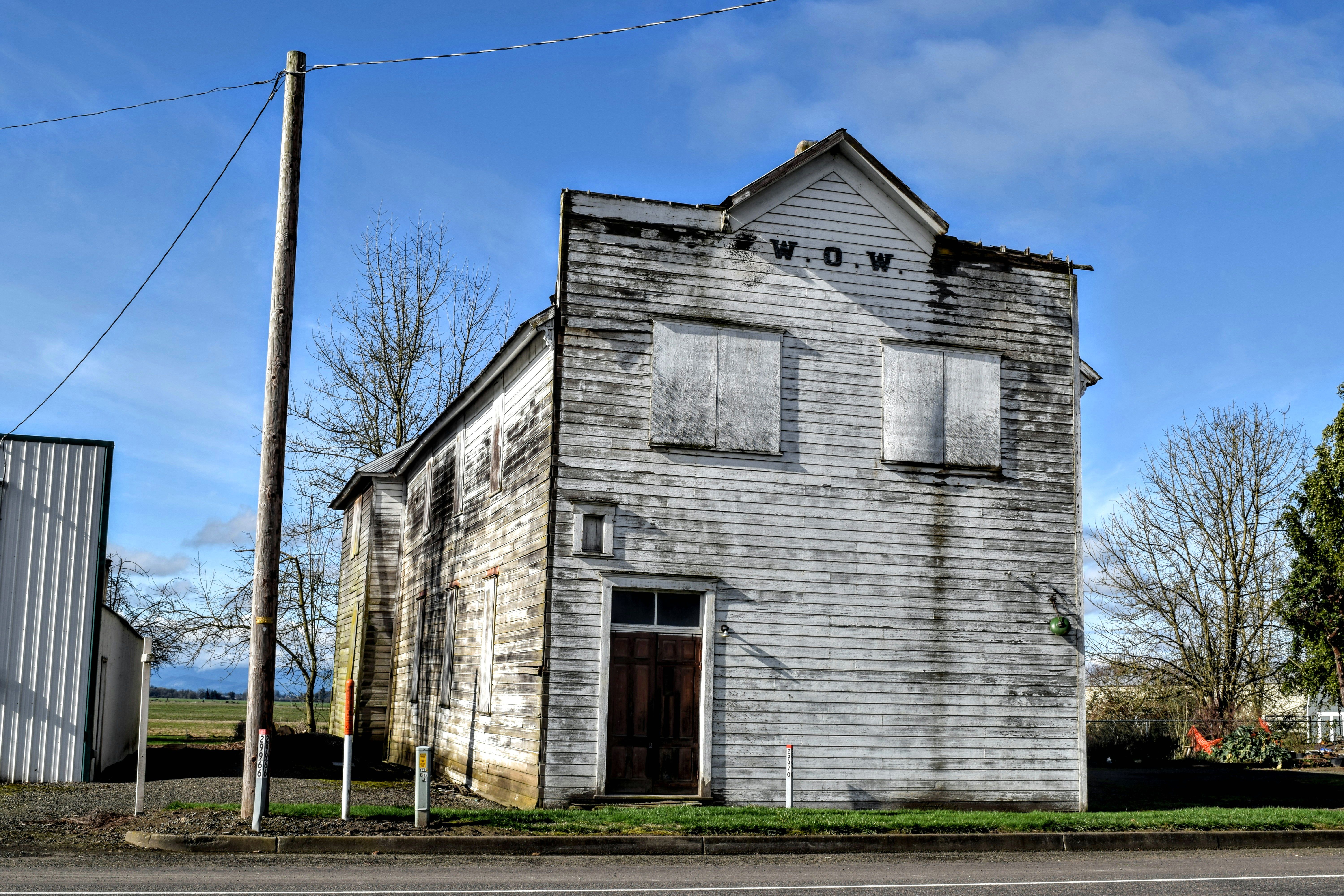
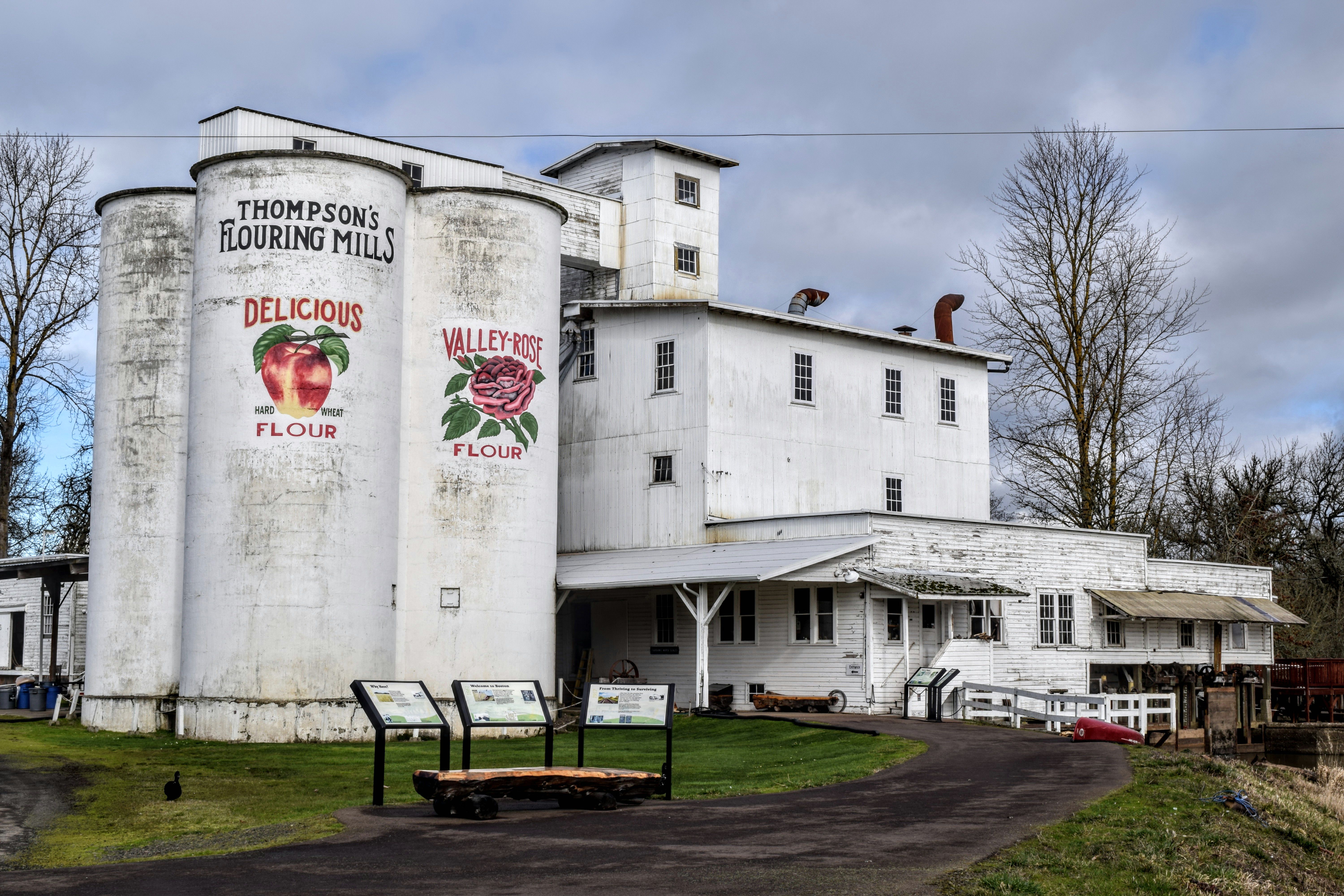
Some towns were moved from one area to another in order to be located on the railroad line, such as the town of Boston (approx. 12 miles south of ALBANY on 99E) which was moved, buildings and all, to Shedd when the Oregon and California Railroad came through the region. Shedd and the still-functioning water-powered flour mill on Boston Mills Road are both listed on the National Registry of Historic Places

A few ghost towns in the valley were simply stage coach stops to begin with, such as Dolph and were no longer needed when stage coaches were replaced by automobiles. What went on in these truly ghost-like ghost towns we may never know by any other means then word of mouth. There are no falling down buildings, no century old barns, no moss-covered watering troughs; nothing tangible to attest to the people who built these towns.

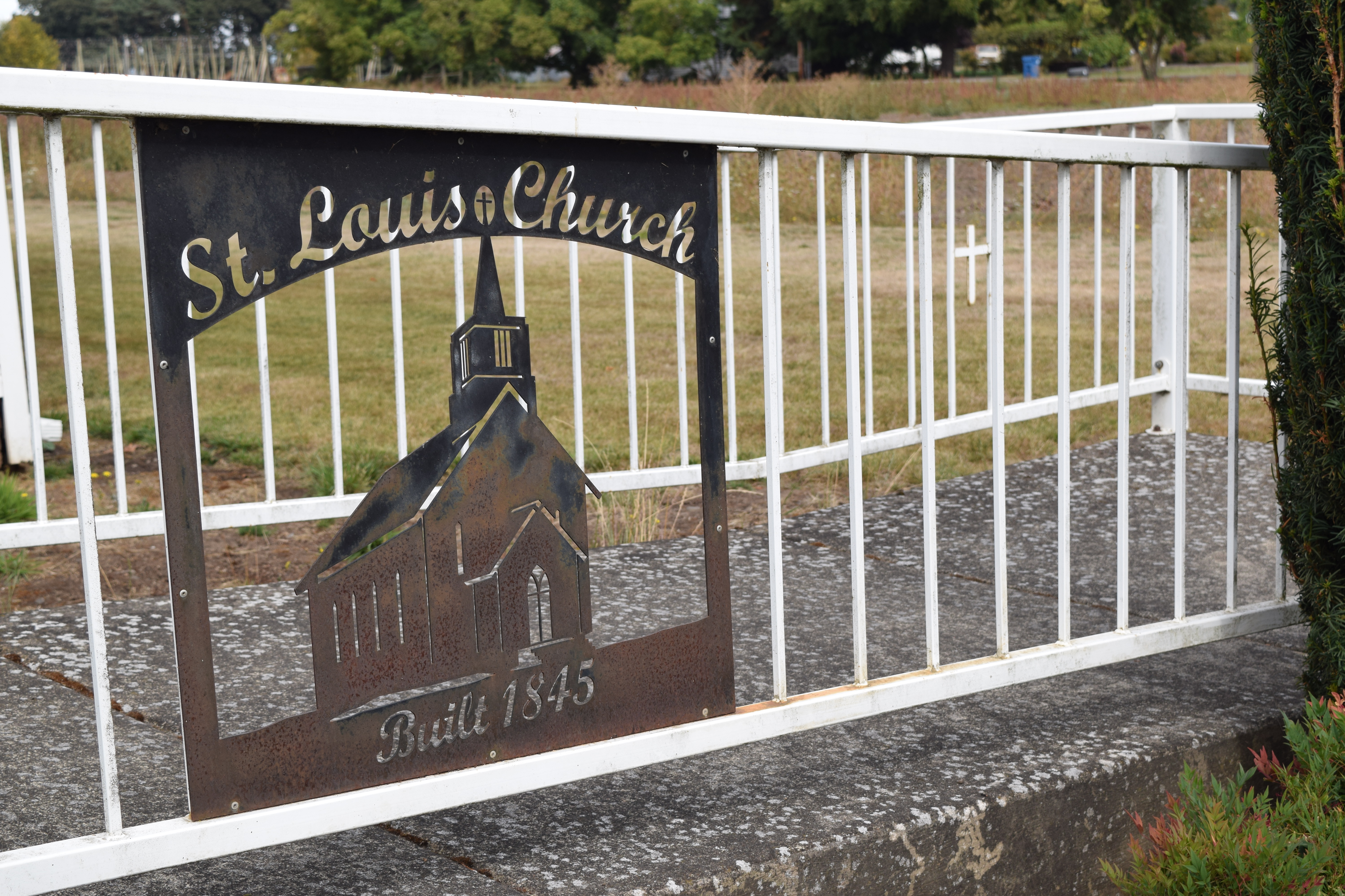
The town of Oxford was platted (mapped out)“ by Robert “Doc” Newell, whose reconstructed home is currently just a few hundred yards from modern day Champoeg State Park and is listed on the National Register of Historic Places. The center of the ghost town of Oxford is near the present-day memorial in Champoeg State Park which commemorates the group of people who, in 1843, elected (52 for, 50 against) to make Oregon a provisional territory of the United States. Butting up right against the mighty Willamette, Champoeg State Park is a ghost town worth seeing for its splendor as well as its historical significance.

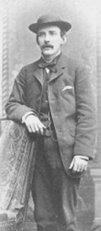
Traveling south from Dallas along King’s Valley Highway will bring you to quite a few interesting historical sites and at least two ghost towns; KING’S VALLEY and HOSKINS. Also of interest in this vicinity are the Ritner Creek Covered Bridge, King’s Valley Pioneer Cemetery and Fort Hoskins. The Highway’s namesake, Isaac King (1819-1866) died a death that has been a popular mystery of the area since it happened. Many ascribing King’s death to an accident, while some say it was murder while others report suicide. King is not buried in the King’s Valley Pioneer Cemetery but in a small family plot on the King’s donation land claim.

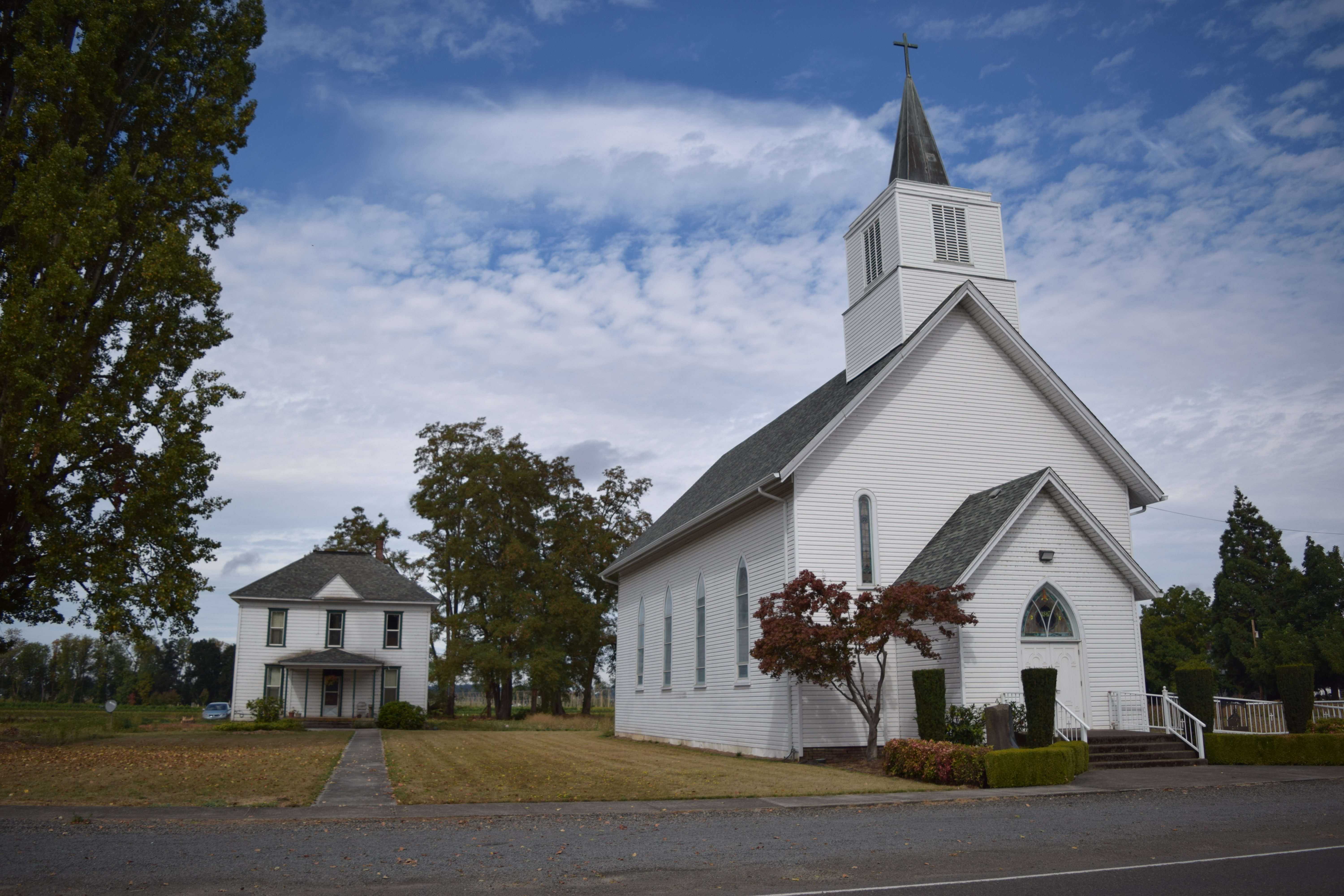
Aurora, Mabel, Independence, Zena, and Butteville still offer structures to whet the appetites of the historically curious, the architecture enthusiast, the tourist, or the explorer. Whatever your interest may be, there is no time like the springtime for getting out and touring the Willamette Valley and seeing its heritage for yourself.

*Originally published in the Spring 2016 Edition of Willamette Valley Life (pp. 8-9).

Aurora Oregon. May 2017 at a Jane Kirkpatrick author signing/historical event.

St. Louis, OR

Just a hop skip and jump westward over I-5 from Gervais OR stands a church which marks what was once known as St. Louis, one of the oldest Euro-American communities in Oregon. Named for the king of France, St. Louis consisted of a post office, a store, a school, a cemetery, and of course a church. The current church standing near the corner of Manning Rd. and St. Louis Rd was built in 1880 to replace the original log building constructed in 1845; the original church having burnt down in 1880.

An interesting thing about that original log structure church is the fact that Madame Marie Dorion was buried in it and with its loss also came the loss of the grave marker of one of the bravest pioneer women to trek the Oregon trail.  Madame Dorion was a Native American woman of Iowan Indian and French-Canadian descent whose commitment to sticktoitiveness is legendary.

In 1811 Marie Dorion’s husband, the interpreter Pierre Dorion, was commissioned to join the Astor group on its western journey in an attempt to find an overland route to Oregon from the east. With vigor and might, Marie convinced the powers that be that she should join the group as well, her main argument being that their two sons needed their father.

Through many hardships, skirmishes, and even with an attempt to save the life of one of the members of the party within minutes of discovering her own husband’s lifeless body, Dorion stuck to her commitment to her children. By 1845 she was living in the area known as St. Louis OR, where she was buried upon her death.

This is the church built in 1880 to replace the log structure. The metal marker on the front of the church refers to the original building.


stlouischurch


DSC_0783number2

DSC_0794

DSC_0746


DSC_0795

The Oregon City Municipal Elevator

The Oregon City Municipal elevator is the only outdoor municipal elevator in the United States, and there are only four such elevators in the world. It has been argued that this elevator is also the only vertical street in the United States because it carries people 130 feet up or down to the higher or lower street..

DSC_0328

As Oregon City quickly outgrew the available land fronting the Willamette River, the people began to build more town up above the cliffs, building steps that they had to trudge along in order to get there. The steps were laborious and muddy and quite an ordeal, especially with animals and wagons, so the people got the idea to build the elevator, which came off smashingly.

Sam Brown House

DSC_0121

A couple of years ago I took a picture of the barn, (“The Willows”) on the Sam Brown House property and posted it in one of the “Oregon” groups I enjoy on FB. One of the commenters mentioned that she had just photographed the house on that property and that she didn’t even notice there was a barn near it.

I hadn’t even noticed there was a house!

I finally made it back over there yesterday and found that, yes indeed there is a house. It is the Sam Brown House which is waiting urgently (not patiently as can seen from the above photo) for restoration.

Also, you can see in the above photo that there is indeed a barn on that property as well.

Information about the upcoming restoration and how to donate to the restoration can be found here.


A Beautiful Memorial

This is a memorial resting on the grounds of the Oregon State Hospital. Housed within this revamped BLDG 60 are over 3,000 copper urns which were moved around for many years on the Hospital grounds until finally resting within the walls of this building. At one time, building 40 was used to quarantine the terminally ill patients.

memorial

Three sides of the memorial are surrounded by a wall which holds newer urns. Names and dates of birth and death, if known, are engraved on the caps of the urns. When a family claims the cremains, a copper tube is placed in the space to commemorate the homecoming.

memorial2

Below is a closer view of the copper canisters which stored the cremations prior to their being placed in the ceramic urns, then in the wall.

output-2


This is some of the wire artwork that surrounds the structure. Copper tubes replace the ceramic canisters when a family member is claimed.

20170213_165742


Preventing Valley Floods (mostly)


There are thirteen dams which make up what is known as the Willamette Valley Project; a series of dams built and operated by the Army Corps of Engineers. It is these dams which prevent (most years) the flooding of the Willamette River we knew in the past. From Cottage Grove to Detroit, these dams are:

Cottage Grove

Dorena

DSC_0162

Hills Creek

Lookout Point

Dexter

Fall Creek

Fern Ridge

dsc_0500

Cougar

Blue River

Foster

Foster

Green Peter

foster6

Detroit

DSC_0068

and Big Cliff

DSC_0108

Thanks to the work of these magnificent regulators of the currents which run into the Willamette River, the Valley floor has seen a lot less flooding than it used to.

If you are so inclined, enjoy this article expounding on the benefits of the dams. dams on the willamette’s tributaries.

She Celebrated Nature’s Cathedral

Perhaps some of the most majestic structures of the Willamette Valley are those that are home to nature’s creatures and plants. In the early 20th Century it was a precocious 5 year old in the Cottage Grove area who began to put such ideas to paper, but it wasn’t until Benjamin Hoff, of Tao of Pooh fame, explored and delivered an engaging biography of this girl genius that we could truly appreciate Opal Whiteley’s acumen.

img653

Benjamin Hoff’s biography of fellow Oregonian and nature lover, Opal Whiteley, has aided in dispelling many myths concerning Whiteley’s mental stability while adding credence to many of her early fanciful claims. Web sites, memorials, parks, and books about Whiteley have become popular in recent years and she is becoming one of the more intriguing literary figures of the 20th century. So many, many, questions spring from her writings and lectures. Was she schizophrenic?  Adopted? A genius? Did she talk to fairies among the fir forests surrounding her home near Cottage Grove? It is entirely possible that a more interesting, multi-layered individual may not have ever graced the natural cathedrals of the Willamette Valley.

Steve McQuiddy has written a nice piece about Whiteley which can be downloaded here, and the University of Oregon maintains a fantastic web site which contains Whiteley’s complete diary here. Cottage Grove maintains  The Opal Center, a venue operating within the strictures of Whiteley’s philosophy of art/nature/knowledge accessibility to all. The Cottage Grove Historical Society has a concise yet excellent bio of Whiteley on their websiteopal_whiteley

The Story of Opal can be read by clicking on the title, thanks to Project Gutenberg.

Walking Tour of Willamette, Oregon

or_willamette_valley


It doesn’t look as if  West Linn Oregon is technically in the Willamette Valley. Because West Linn and Oregon City are sooo very close to the Willamette Valley, I am going to include them on this WV blog just this once. There is a historical section of that area which used to be the town of Willamette Falls, a name that was shortened to Willamette at some point. There are many historic buildings to see, as well as a historic meteorite  (replica).

Just take a look at the brochure linked below and see if Willamette doesn’t make it’s way onto your bucket list.

walking_tour_of_willamette_neighborhood_brochure-1

Poems From Old Champoeg

Having just renewed my library card (I have a fee based card on account of living outside the city limits), I went wild over at the shelving area known as the Hugh Morrow section. Okay, it was a toned-down wild, as I was in the library for goodness sakes.

I brought home a lot of books. Some with maps, some with newspaper clippings, some with old photographs, etc. All those kinds of books that history buffs like to read.

I found something that surprised me while I was handling every book I could on those book shelves. I found a book of poetry. Poems about Oregon. Poems about History. Poems about…the history of the Willamette Valley!!!

I have read this book, and plan to read it again before I return it. I would actually like to buy a copy, but can’t find it anywhere. I don’t know how many were printed, and all I can find out about it is that it was self published by Clinton Frederick Blake in 1925, but I believe the author used a pen name. I will surely search the records, if at all possible, of the sources that the author mentions, but so far I have come up with no leads about this book or the author. I wonder why the poets were not named, because in the one edition of “The Lariat (1927, volumes 9-10)” that I found online, the poets were indeed mentioned. Of course, the poems from “The Poems from Old Champoeg” were not in that particular volume of the “The Lariat;” they are from a previous edition.

This book is a curiosity indeed!

Please, read and enjoy this book.

poems-from-old-champoeg


Glen Mills

Here is a short article about Glen Mills, an inspiration to countless people, who has inspired  This kickstarter.


Boston and Shedd

About fifteen miles south of Albany along HWY 99 E is the town of Shedd. Shedd is a town which used to be located about a mile and a half due east of its current location and was called Boston. Now, when the railroad was coming up through the area the tracks weren’t due to lie down in Boston, so the good folks of Boston picked up their town, buildings and all, and headed west where today, sure enough, the railroad tracks run right through the middle of town. The town of Boston is a State Park which is open for tours nearly every day of the year. During these tours, people can see some of the buildings that stayed put for one reason or another and also tour the mill and watch the water-power produce flour.


DSC_0356


DSC_0296


DSC_0258

Early Agriculture from West Salem to Dayton


Picture2

The Kalapuya tribes were the first to cultivate crops in the Willamette Valley. Because they were a semi-nomadic people, they did not build any permanent structures which will attest to either their ingenuity or their conservation-minded agricultural practices, but it is known that the Kalapuya tribes maintained a practice of flash-burning, or controlled field burning, which made pastureland conducive to the growing of camas, tarweed, berries, and hazelnuts.

Not only were the Kalapuya astute at manipulating their environment for growing produce, but all of the fresh vegetation in turn attracted deer, elk, and other wild game which they hunted for food and clothing.

The Oregon trail brought thousands of settlers into Oregon City between 1840—1850, but it was the Willamette Valley that drew the farmers.

Being within such close proximity to the Willamette River, the area NW of
Salem is a region which exploded with farms whose wheat and produce was so abundant that much of it was often shipped down to the California gold miners during the Gold Rush. The city of Lincoln (named for Abraham Lincoln, and also known as Doak’s Ferry) was a town that shipped out more wheat than any other Willamette River City other than Portland.

Much of the farmland of this area is now blushing with vineyards, nurseries, fruit trees, and berries. According to the Hazelnut Growers of Oregon, the Willamette Valley is where 99% of all hazelnuts grown in the United States come from. The Willamette Valley’s rich soil coupled with the gentle climate and abundant rainfall all work together to make the region ideal for agriculture.

SONY DSC
A barn between W.Salem and Dayton

Robert Stuart Wallace

Picture1

Robert Stuart Wallace (1851-1891)


Just north of the hub of West Salem is a development of homes known as “Salem Towne.” This area was not always known as home to hundreds of people, for it was these 330 acres which Robert Stuart Wallace once developed into a thriving pear farm with its own packaging plant.

In the short time that Wallace lived in Salem, in fact in his short life of merely 41 years, Wallace was successful in many things both in Salem and before his arrival in Salem.

While living in Chicago, Wallace did quite well for himself as a seed merchant, then he became an accomplished grain merchant, shipping flax as far as France and Germany. When told by his doctor that his ailing health would improve if he would leave his stressful work, Wallace moved to Salem Oregon.

Mr. Wallace spent the last six years of his life in Salem Oregon, though it does not seem that he slowed down much. As the 847 word obituary published in the Oct. 31 1891 Oregon Statesman Newspaper can attest, Mr. Wallace had quite a busy life in Salem.

Besides planting and maintaining fruit orchards, Mr. Wallace was also a key figure in getting the Willamette Bridge built in Salem, he helped start a local cannery as well as a fruit evaporator (drier).

Along with the growing of fruit and processing it in Salem’s first cannery, Mr. Wallace was also the founder and president of the Capital National Bank in Salem, instrumental in the development of Salem’s water supply and was also involved in the generation of electricity for Salem residents via a water wheel generating system near Jefferon, Oregon (Sydney Power Company) which operated a flour mill while running a river powered electric generator.

Picture2

Capital National Bank (Pioneer Trust)

“What we seek, at the deepest level, is inwardly to resemble, rather than physically to possess, the objects and places that touch us through their beauty.”

—- Alain de Botton, “The Architecture of Happiness.


SONY DSC
Modern-day barn just north of Salem Towne.

State HWY 221

12x8wallacerdbarn2


The 21-mile long stretch of road known as the Salem-Dayton Highway is a relatively flat-road bike ride. There are just a few moderate hills, and these are nearer to  W. Salem than to Dayton. The traffic is heavy at times, and the shoulder seems narrow when all those large trucks begin passing, but as the rider gets nearer to Dayton there is a nice, wide bike path, which is a lot less terrifying for those of us who are amateur bicyclists. A LOT.

Wallace RD NW leads from W.Salem to the Willamette Valley Cheese Company where you can sample an array of farmstead cheeses, to the Wheatland Ferry which carries all manner of vehicles across the Willamette River, and to the Maud Williamson State Park which is home to the historic farmhouse of the acreage’s original donor (Maud Williamson), then onto some Dayton Oregon Wineries which proffer numerous wine tastings. It is hard to believe that all this can be found on that short stretch of road sometimes known as Oregon State HWY 221. Seeing some of the most beautiful scenery in the upper Willamette Valley is a certain bonus while traveling through here.

According to their website, Willamette Valley Cheese Company is one of the first cow’s milk farmstead cheese makers in Oregon, defining “farmstead” to mean that they milk their own cows and make it into cheese that same day. The family at Willamette Valley Cheese Company has been in the dairy business in the United States since 1962,
having for many generations been dairy farmers in Holland.

Among the award-winning cheeses made at Willamette Valley Cheese Company such as Havarti, Eola Jack, Farmstead Fontina and Gouda, are their much sought after specialty cheeses such as French Prairie Brie and Aged Asiago. While visiting and sampling cheese, perhaps you will notice the heritage barn which sits on the farm.

The Wheatland Ferry has been ferrying people across the Willamette River between Marion and Yamhill counties for over 150 years. The first ferry was a wooden raft powered by men who controlled the ferry with wooden poles. Daniel Matheny started the ferry and each new boat is named after him.

Across HWY 221, just west of the Ferry landing is Maud Williamson State Park, which is home to a sprawling family of second growth Douglas Fir and a historic farm house, and in the spring, trillium grow abundantly (please don’t pick the trillium. They can die and take years to recover, if at all).

According to a recent map of wine makers, there are 7 wineries in Dayton Oregon, so it may not be possible to tour all of them in one stint. Touring at least one would be a wonderful way to cap off visiting all the other highlights along this route. After noting the beautiful scenery along with all those charming barns during this tour, a glass of wine just might hit the spot.


Note: The route I took when I first traveled this area and took photos was from River RD N. to Wheatland RD, across the ferry and S. back to Salem along 221. I did not make it to Dayton during this trek. I did, however, stop to buy some amazing jalapeno jack  cheese at the Willamette Cheese Factory and was captivated by Daum’s big red barn pictured here.

A few fruitless rides

DSC_0549

I have found that not all country roads lead to barns. Imagine my disappointment, living here in the abundant valley of the Willamette, to find that I can’t just randomly choose a road that points toward agriculture and magically come across a picturesque structure.

Having spent a few hours searching for “that picture,” has provided me with much needed exercise, helped me clear stress from my mind, and has been all-around good for me despite coming up empty-handed, photographically speaking. So, the searching is really not a waste of time.

My last ride was out Highway 22, toward Dallas. It is an ideal bike ride; the bike path is wide, there is an ample sidewalk from W.Salem to the Oak Knoll Golf Course, and the inclines are merely fun – not truly exhausting. There is one conveniently located barn between Salem and the pedestrian bridge near Rickreal RD, and I failed to get a good shot at it. I had the wrong lens, the angle through the trees was wrong, I needed to be on the other side of the street, etc. Honestly, though, I am not going to run across a busy freeway, thanks, but no thanks. I will try again soon for that one.

As I am committed to short rides right now, due to the fall weather, I did not go any further than the pedestrian bridge by the golf course and back. I did find that the pedestrian bridge was actually a rest stop for bicyclists that was dedicated to a decorated naval aviator who was also a bicycle enthusiast.

11225314_945975615437665_311068429851606537_o 12232863_945975612104332_981976599524671459_o

So, what’s with the barn photo at the beginning of this post? Well, it’s one that I got a couple of excursions ago out on State Street near 63rd.

Blog at WordPress.com.

Up ↑